


Method
There is still no authoritative method of establishing length of marked ski runs. It is not a subject of the well-known seals of approval which are awarded in Tyrol f.e. in relation to safety and marking of slopes. The length of marked runs is the overall length of all downhill runs in the ski area.
These include:
- Pistes: A piste is a generally accessible run, suitable and meant for descending it with skis or snowboard that is usually prepared, always marked, controlled by ski patrol after lift closure and secured from atypical hazards, particularly avalanche danger. A piste is graded by degrees of difficulty and includes open runs as well as catwalks (usually forestry or farming roads).
- Off-piste ski routes: A ski route is a generally accessible run, suitable and meant for descending it with skis or snowboard that is marked and secured from avalanche danger, but is neither prepared nor controlled by ski patrol after lift closure.
- Special areas: Snowparks, Snowcross, Funslopes, Kidsparks etc
In order to qualify for the award of the Seal of Approval ‘Verified Length of runs’, a measurement is taken of the median line of the pistes and ski routes, i.e. the line in the centre of the respective piste, between the right and left border of the piste. If the piste or ski route is inclined, this does not always equal the fall line.
Each section of the piste/ski route is allowed for only once and independent of its width, even if a skier has to pass along them on numerous occasions to explore all options possible for a downhill run. Thus it is avoided that small clusters of trees on some pistes contribute to an unrealistic expansion of the overall length of runs. In this respect, we take on the recommendations of FIANET and OITAF.
In snowparks, parallel lines are considered separately if their character is different.
The measurement of runs is carried out by inspection with GPS on site or by using desktop mapping software. The course of the pistes is established by using various analogue and digital sources. Pistes (including catwalks) and ski routes (excluding unmarked and not secured high-alpine routes which are included by some resorts on their trail maps) are being considered based on current trail maps. If it was possible to establish further runs (f.e. maintained pistes on aerial images, GIS data or personal site inspection), these have been included. Particularly in the larger ski resorts, it is not possible to include all of them on a printed trail map.
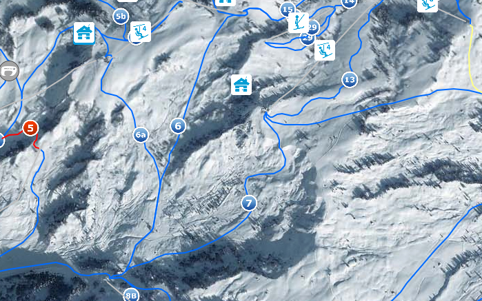
The digitized slope courses were exported and measured with GIS. The overall length of the slopes is the sum of the length of all sections (Source of picture: www.dolomitisuperski.com).
Contact
Montenius Consult
Christoph Schrahe
Diesterwegstraße 29
51109 Köln
Phone.: +49 221 94653533
Fax: +49 221 94653534
Mobile: +49 177 8340052
Email: schrahe [at] montenius.com